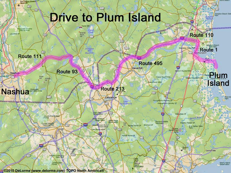
directions to Plum Island
( Parker River National Wildlife Refuge )
Location:
Northeastern MA coast
south of the city of Newbury, MA
Driving (one way from Nashua, NH):
Distance: 45 miles
Time: 1 hour 15 minutes
Parking: at visitor parking lot (entrance fee)
If you use a car GPS, here are the Parking Lot #2 coordinates (in degrees and minutes):
N 42 47.226
W 70 48.526
Roads:
- Route 111 east
- Route 93 south
- Route 213 east
- Route 495 northeast to Exit 55
- Route 110 east (for 3.1 miles)
- Route 1 south (for 2.4 miles)
- Water Street east (for 1.5 miles)
- Plum Island Turnpike east (for 1.8 miles)
- Sunset Drive south (for 0.6 miles)
- Refuge Road south (for 0.6 miles)
Hiking (round trip):
Distance: 1 mile (or more)
Time: 1 hour (or more)
Trails: various short nature walks plus six miles of sandy ocean beach
Trail Map: Parker River NWR
Nature Walk:
Flat terrain and ocean beach
Winter Accessibility:
Portions of the refuge may be closed during critical wildlife habitat times.
(The entire beach is usually closed in April, May and June.)
Back to: Plum Island photos
or NH Mountain Hiking