NH Mountain Hiking
< Bushwhacking Basics
< Magazine Articles
NH Mountain Hiking
< Bushwhacking Basics
< Magazine Articles
NH Mountain Hiking
< Bushwhacking Basics
< Magazine Articles
Article by Fred Shirley reproduced from the Winter 2006/2007 issue of Heart of New Hampshire magazine.
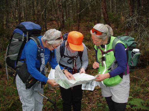
Where are we? Somewhere between
trailhead and peak, a trio of bushwhackers
studies the topo map.
|
Most mountain hikers travel a well--maintained trail to a summit with a fine view. The guidebook and map tell where to go, signs point the way, and it's easy to follow the well--worn path. But, if this becomes just too easy, what's an adventurous hiker to do? Go bushwhacking! Get off the trail, find your own way in the woods and go where few have gone before... Okay, this may sound a little scary. But if you do your homework and learn some basic skills, it can be an exciting challenge and confidence builder. How to get started? The first step is selecting a mountain to climb. Most New Hampshire bushwhackers pick a mountain from the New Hampshire 100 Highest list (www.nhmountainhiking.com/ hike/lists/nh100.html). The list includes all 48 of the state's 4000--plus footers, and 52 more mountains just under 4000 feet. Of these 52 lower mountains, about half have no trails and therefore offer great bushwhacking opportunities. |
The next step is locating the mountain. Most are listed in the AMC White Mountain Guide. Use the index to find a brief description of the mountain, then pull out the appropriate map to locate it. Usually there is a trail that will take you close to the summit, providing you a launching spot for your new adventure. If you need to go very far off trail, you will want to get the U.S. Geological Survey detailed map of the area. You can search the Web for clues and hints from previous hikers who may have traveled to these less trodden destinations before. Now, for the "skill" part. In addition to the preparations you would make for any mountain hike, you will need to master map--and--compass navigation. You might want to take a class in orienteering, or perhaps go out with a friend who is willing to help you learn. While map and compass are essential, some bushwhackers also use supplementary devices: an altimeter (to tell how high up you |
are and match the map's contour lines) or GPS (to pinpoint your location on the map). There are physical challenges, too. In addition to the going--up--hill part, the lack of a trail can make the going tough in other ways. Sometimes brush and thickets of trees are so dense you will have to bull your way somewhat blindly through them. Sometimes softwood blow--downs make forward progress an arduous jungle--gym exercise. And in winter, "spruce traps" can unexpectedly snare you, forcing a strenuous recovery! Spruce traps occur where a mantle of snow is perched atop dense spruce--fir saplings, forming hidden voids or pockets beneath the surface that won't support a step, even on snowshoes. A walking stick or poles make a good probe to find such features. |
|
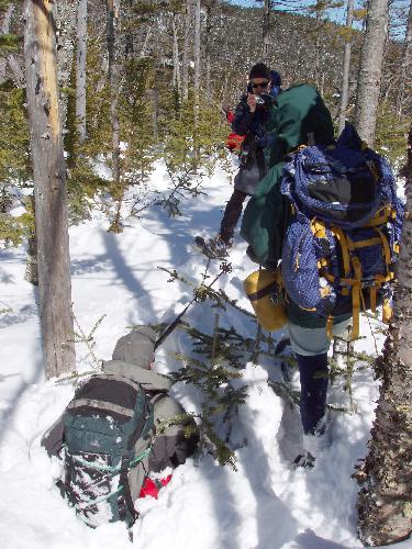
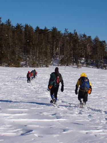
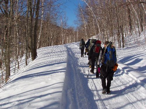
Mts. Lowell and Anderson bushwhack Late in winter, eight of us did a bushwhack to Mt. Lowell and Mt. Anderson. These two mountains on the New Hampshire 100 Highest list are located in the White Mountains near Mt. Carrigain. We started out at the crack of dawn on Sawyer River Road. This access road is closed to cars in winter, but snowmobilers had compacted a nice track that made for easy walking. We continued up the Signal Ridge and Carrigain Notch trails, which were hiker--compacted and also easy going.
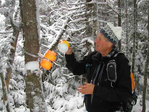
Now, the fun part. We headed off into the woods, up the slope to Mt. Lowell. Most of the time we snowshoed comfortably through open forest on top of deep snow. We even detoured to a shoulder ledge for a magnificent view of Mt. Lowell's steep western side. Then we hit the spruce traps. It is insidious how one hiker can be standing securely on the surface of the snow while his fellow hiker takes an elevator ride down to the ground |
beneath. In the "Spruce trap!" photo, Bill is still standing on his snowshoes, even though his nose is at shin height. We took turns randomly discovering these unwelcome surprises. Finally, we reached the summit of Mt. Lowell with its stunted forest and panoramic view -- the "high" point of our trip. From there we continued over to Mt. Anderson and down to Norcross Pond, where we took a shortcut across the frozen water. Hey, this straight--and--flat part is easier than hiking in summer! We completed our loop by hiking down Nancy Pond Trail, arriving back at our cars at sunset. To "bag" these two mountains we had traveled a total of 12 miles in 11 hours, going fast on roads and trails but slowly through the woods. We drove home, eight tired but happy bushwhackers. Adventure in any season Even without the complications of winter, bushwhacking can be an exciting adventure. Unknown risks, navigation challenges and unexpected natural beauty await undaunted explorers. |
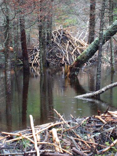
On a bushwhack to Hutchins Mountain, I was surprised by the animal kingdom's premier engineer. Far away from civilization, the local beaver corps had a major construction project going on, transforming the landscape with their dams and lodges. I had never seen anything like it -- almost good enough to be taxed as lake--front property!
|
|
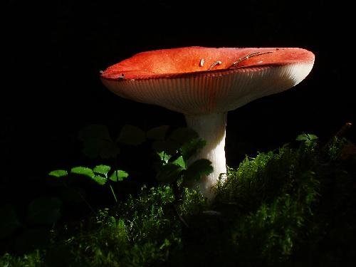
On another bushwhack, to West Osceola, I came upon a different kind of natural wonder. In the deep forest, safe off the beaten path and untrammeled by hikeboots, I found the most gorgeous mushroom ever. A shaft of sunlight bathed it in exquisite light. I'm glad I had my camera! Going on a bushwhack has some of the same elements as a scavenger hunt, or hide--and--seek game. It's like being a kid again. You've got to find your own way to a place you've never been and locate the summit "canister." This is (hopefully) a waterproof container, usually strapped to a tree at eye level, which contains a logbook. Adventurous hikers before you have left their names here, and now you may add yours, too! So, what's to be gained by all this bushwacking? Besides the fun, it's a hiker confidence builder. Remember when you got lost hiking on a regular trail and were scared? After you've been "lost" on purpose and navigated successfully through miles of woods, you develop a forest friendship. Sure, you still need to be careful in the mountains, but chances are you will never be lost for very long again. You can find out about more bushwhacking adventures on my NH Mountain Hiking website www.nhmountainhiking.com. |
Hike Safely!
Mountain hiking has inherent dangers.
You could get hurt or lost, or both.
If you plan to hike in New Hampshire's mountains,
you may want to check out the Appalachian Mountain Club's
website (www.outdoors.org)
for
Hiking and bushwhacking in winter present more severe risks. It's a lot easier to fall and get hurt in icy conditions, and a lot easier to get lost off trail. And if you do get hurt or lost, you run the added risk of freezing out there in the middle of nowhere. So, please, don't head out on a winter bushwhack unless you know you have had plenty of experience at this and are properly prepared. If you are unsure of your own skills, hike with a group you know is experienced and prepared for bushwhacking.
|