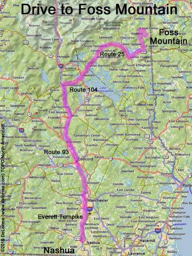
directions to Foss Mountain
Location:
In eastern NH, near the Maine border
Southeast of the town of Eaton Center, NH
Driving (one way from Nashua, NH):
Distance: 120 miles
Time: 2 hours 50 minutes
Parking: at roadside parking lot
Roads:
- Everett Turnpike north
- Route 93 north to Exit 23
- Route 104 east
- Route 3 north
- Route 25 east
- Route 153 north (for 10.0 miles)
- Brownfield Road east (for 1.6 miles)
- Bull Pasture Road south (for 1.2 miles)
- Stewart Road west (for 0.3 miles)
- Foss Mountain Road south (for 1.9 miles)
Hiking (round trip):
Distance: 3/4 mile
Time: 30 minutes
Trail: unnamed trail up through blueberry fields
Online Trail Guide: FranklinSites
Trail Map: Foss Mountain blueberry picking map
Hiking (one way, up to the summit):
Distance: 1/3 mile
Vertical: 250 feet
Time: 15 minutes
Summit:
Dome summit with excellent panoramic view
Height: 1647 feet
Winter Accessibility:
Access road (Foss Mountain Road) may be partially closed in winter, increasing hike length.
Back to: Foss Mountain
or: NH Mountain Hiking