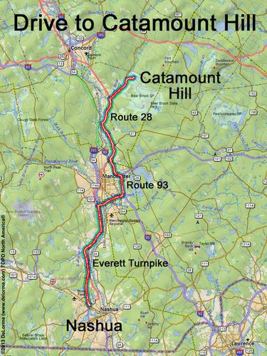
directions to Catamount Hill
Location:
Southern NH, in Bear Brook State Park
Northeast of the town of Hooksett, NH
Driving (one way from Nashua, NH):
Distance: 35 miles
Time: 45 minutes
Parking: in parking lot near park entrance gate (fee during active summer season)
If you use a car GPS, here are the parking lot coordinates (in degrees and minutes):
N 43 09.762
W 71 23.309
Roads:
- Everett Turnpike north
- Route 101 east
- Route 93 north to Exit 9N
- Route 28 north (for 11.0 miles)
- Deerfield Road east (for 0.9 miles)
Hiking (round trip):
Distance: 2 1/2 miles
Time: 1 1/2 hours
Trail: One Mile Road and Catamount Hill Trail
Trail Guide: AMC Southern New Hampshire Trail Guide
Trail Map: Bear Brook Summer Hiking Trails.
GPS Map: Catamount Hill GPS Track
Hiking (one way, up to the summit):
Distance: 1.2 miles
Vertical: 400 feet
Time: 45 minutes
Summit:
Directional view from near-summit ledge
Height: 721 feet
Winter Accessibility:
The trailhead parking lot may not be plowed in winter, in which case the
snowmobile parking lot may be available (0.4 miles west on Deerfield Road).
If you use a car GPS, here are the snowmobile lot coordinates (in degrees and minutes):
N 43 09.647
W 71 23.797
Back to: Catamount Hill photos
or NH Mountain Hiking