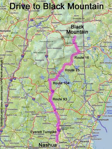
directions to Black Mountain
Location:
South of Pinkham Notch
North of the town of Jackson, NH
Note: this mountain creates confusion, being on two different lists
and meaning two very different hiking objectives:
1. The shoulder (2757-ft) is on the revised NH 52 With-A-View list
and is reached by a short trail.
2. The summit (3404-ft) is on the NH 3000-Footer list
and requires a serious bushwhack.
Driving (one way from Nashua, NH):
Distance: 130 miles
Time: 2 hours 50 minutes
Parking: at trailhead parking lot
Roads:
- Everett Turnpike north
- Route 93 north to Exit 23
- Route 104 east
- Route 25 east
- Route 16 north
- Route 16A north (for 0.6 miles)
- Carter Notch Road north (for 4 or 5 miles)
Hiking (round trip to shoulder via trail):
Distance: 3 miles
Time: 3 hours
Trail: Black Mountain Ski Trail
Trail Guide: AMC White Mountain Guide
Hiking (round trip to summit via bushwhack):
Distance: 6 miles
Time: 6 hours
Trail: Bog Brook Trail and bushwhack
Trail Guide: AMC White Mountain Guide
Topo Map: Jackson NH 24k USGS quadrangle
Summit:
Summit (3404 feet) is a huge raspberry field with many limited directional views
Shoulder (2757 feet) is wooded with a limited view
Winter Accessibility:
Available year round, but the access road (Carter Notch Road) may be
closed in winter, increasing hike length
Back to: Black Mountain photos
or NH Mountain Hiking