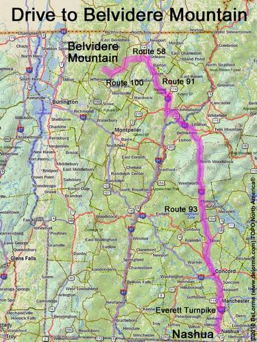
directions to Belvidere Mountain VT

Location:

In far northern Vermont
North of the town of Eden, VT

Driving (one way from Nashua, NH):

Distance: 200 miles
Time: 3 hours 20 minutes
Parking: at trailhead parking lot
If you use a car GPS, here are the trailhead parking lot coordinates (in degrees and minutes):
    N 44 45.839
   W 72 35.271
Roads:
 - Everett Turnpike north
 - Route 93 north
 - Route 91 north to exit 26
 - Route 58 west (for 13.4 miles)
 - Route 100 southwest (for 9.2 miles)
 - Route 118 northwest (for 4.5 miles)

Hiking (round trip):

Distance: 6 miles
Vertical: 2000 feet
Time: 3 3/4 hours
Trail: Long Trail and Forester's Trail
Trail Guide: GMC Long Trail Guide
GPS Track: Belvidere Mountain GPS Track

Summit:

Summit lookout tower with panoramic view.
Height: 3356 feet

Winter Accessibility:

Available year round.
Back to: Belvidere Mountain       or: NH Mountain Hiking